


The unmatched aerial imaging capabilities of thermal drones are transforming numerous industries. Let’s examine the features, applications, benefits, and considerations for purchasing thermal drones in more detail.
Introduction to Thermal Drones
We now view aerial imaging and data collection very differently as a result of the introduction of thermal drones in recent years. A thermal drone’s specialized thermal imaging camera detects heat signatures emitted by objects, in contrast to a traditional drone equipped with a standard camera. By allowing users to see temperature variations in the surrounding environment, this cutting-edge technology opens up a wide range of applications in a variety of sectors.
By absorbing infrared radiation that objects emit, thermal drones function. Thermal cameras on drones can detect and measure infrared radiation, which is emitted by any object with a temperature higher than absolute zero. Thermal drones provide thermal maps that show temperature variations across various surfaces by translating these measurements into visible images.
Thermal drones can be used for a variety of tasks, such as search and rescue operations, monitoring agriculture, wildlife conservation, and building inspections. These drones are an invaluable tool for capturing images of objects such as anomalies, heat sources, and temperature variations that are invisible to conventional cameras and the human eye.
The ability of thermal drones to function well in difficult environmental conditions, such as dim light, smoke, or fog, is one of their main advantages. This makes them essential resources for professionals operating in low-visibility industries, researchers, and emergency responders.
How Thermal Drones Work
Comprehending the internal mechanisms of thermal drones is imperative to appreciate their importance and prospects across diverse sectors. The thermal imaging camera, which is the brains behind thermal drone technology, is unique among cameras in that it can identify objects’ emission of infrared radiation instead of visible light.
Thermal cameras, sometimes referred to as thermographic or infrared cameras, are made up of several sensors that identify infrared light falling within a particular wavelength range. The camera’s sensors detect and translate infrared radiation from an object into electrical signals.
After that, the electrical signals are converted into a visual depiction of temperature variations by the camera’s onboard processor. Usually, this representation is shown as a false-color or grayscale image, with various hues or tones denoting varying temperatures.
Thermal imaging is a method that makes it easier to translate infrared radiation into visible images. Every object in thermal imaging must emit infrared radiation in direct proportion to its temperature. Through the measurement of infrared radiation intensity emitted by scene objects, thermal cameras can produce a thermal image that is capable of accurately representing surface temperature variations.
Thermal drones use this technology by mounting thermal imaging cameras on unmanned aerial vehicles (UAVs). These drones can capture thermal images from a range of heights and angles thanks to their stabilizing mechanisms and flight control systems.
Real-time processing of the thermal data taken by the camera is done by the thermal drone’s onboard computer. To create a visual representation that is shown to the drone operator in real time, the temperature readings must be analyzed.
After that, the operator can use the thermal images to interpret the environment and find hotspots, cold spots, or anomalies. Numerous applications for this information exist, such as:
- Identifying heat sources in search and rescue operations
- Monitoring crop health and irrigation needs in agriculture
- Detecting structural defects in building inspections
- Tracking wildlife movements in conservation efforts
Applications of Thermal Drones
Thermal drone’s unmatched capabilities in aerial imaging and data collection have revolutionized many industries. Thermal drone applications are numerous and varied, ranging from infrastructure inspections and agricultural monitoring to search and rescue operations. Let’s examine some of the main domains in which thermal drones are having a big influence:
Search and Rescue
In search and rescue missions, time is of the essence. To locate missing or survivors in hazardous or isolated regions more quickly, thermal drones are a critical tool. These search and rescue teams greatly benefit from these drones’ thermal imaging cameras, which allow them to detect body heat signatures even in dimly lit areas or among dense vegetation.
Thermal drones allow search and rescue squads to cover large areas rapidly and efficiently, cutting search times and improving the likelihood of success. Due to their ability to detect heat sources associated with human presence, such as body heat or vehicle engines, thermal drones are useful in both locating individuals in need of assistance and possibly saving lives.
Agriculture
Drones with thermal capabilities are transforming crop management and agricultural monitoring. These drones provide useful information about crop health, pest infestations, and water stress by using thermal imagery of farming fields. Farmers can identify areas that need intervention, optimize irrigation schedules, and maximize crop yields with the help of this data.
With the aid of thermal imaging, farmers can identify regions of disease or stress that may not be visible to the unaided eye by measuring even the smallest temperature variations throughout their fields. Farmers can avoid crop losses and preserve the health and productivity of their crops by proactively identifying these issues early on.
Building Inspection
Thermal drones provide a low-cost, non-invasive way to check infrastructure and buildings for leaks in the plumbing system, energy inefficiencies, and structural flaws. Drones with thermal imaging cameras attached can detect temperature anomalies, which could point to problems like inadequate insulation, moisture intrusion, or heat loss.
Drone thermal inspections provide engineers and building inspectors with a more accurate and efficient way to evaluate the state of structures than conventional methods. To maintain the security and durability of structures and infrastructure, inspectors can detect possible issues with thermal imaging before they become more serious. This enables prompt repairs and maintenance.
Wildlife Monitoring
Thermal drones are an indispensable tool in the fight against wildlife poaching and deforestation, tracking endangered species, and monitoring animal populations. Even in thick vegetation or at night, conservationists can find and follow animals using thermal imaging in their natural environments.
Thermal drones collect useful information on population dynamics, habitat utilization, and behavioral patterns by taking thermal images of wildlife populations. This data is crucial for developing conservation strategies, locating high-value conservation areas, and assessing how well conservation efforts are working.
Benefits of Using Thermal Drones
The use of thermal drones is revolutionizing aerial imaging and data collection, offering many benefits to a wide range of industries. Let’s examine a few of the main advantages of employing thermal drones:
Enhanced Visibility:
The ability of thermal drones to provide unobstructed visibility in difficult environmental conditions, like low light, fog, or smoke, is one of their main advantages. In scenarios where visibility is restricted, thermal imaging cameras can be useful for surveillance and reconnaissance because they can identify the heat signatures that objects emit, in contrast to traditional cameras.
Drones allow operators to see temperature differences between various surfaces even in total darkness or inclement weather by taking thermal images. Users are better equipped to make decisions in real-time due to the increased visibility, which also improves situational awareness.
Rapid Deployment:
One advantage of thermal drones is their rapid deployment, which allows users to assess situations and quickly gather critical information from the air. Unlike manned aircraft or ground-based surveillance techniques, drones are instantly airborne and provide reconnaissance capabilities. They can be launched in a matter of minutes.
This quick deployment feature is especially useful in emergency response scenarios where time is of the essence. First responders, search and rescue teams, and disaster relief organizations can all benefit from using thermal drones to quickly assess the extent of damage, locate survivors, and coordinate rescue operations more effectively.
Cost Efficiency:
By streamlining data collection procedures, thermal drones eliminate the need for equipment, manual labor, and other resources used in conventional aerial imaging techniques. Drones help businesses save time, cut expenses, and increase overall productivity by automating data collection and analysis tasks.
Thermal drones provide a more affordable option than manned aircraft or ground-based surveys in several industries, including agriculture, infrastructure inspection, and environmental monitoring. Drones are a great tool for businesses trying to streamline processes and increase return on investment because of their capacity to cover large areas rapidly and precisely.
Safety:
When conducting surveillance, inspection, or reconnaissance missions, thermal drones increase worker safety by eliminating the need for human intervention in hazardous or inaccessible environments. Drones can access places that people might find too dangerous or impractical to visit, such as unstable terrain, buildings at high altitudes, and disaster-affected areas.
Moreover, accidents or injuries associated with traditional aerial imaging methods, such as manned flights or manual inspections, are reduced when thermal drones are used. By conducting surveys from a safe distance, drones help organizations reduce risks and ensure the safety of their workforce.
Versatility:
With applications in a wide range of sectors and industries, thermal drones offer unmatched versatility. Drones can adapt to a variety of use cases and operational requirements, including environmental monitoring, construction, agriculture, and search and rescue.
Users can tailor their payloads and sensors to match specific requirements and goals thanks to the modular design of thermal drones. Because of their adaptability, companies can use drones for a variety of purposes, from surveying and mapping to monitoring and surveillance, thereby optimizing their use and worth.
Top Thermal Drones in the Market
There are numerous models of thermal drones on the market, each with special features, functionalities, and performance. Let’s examine a few of the best thermal drones on the market right now to assist you in making an informed choice:
DJI Matrice 300 RTK:
The DJI Matrice 300 RTK is a flagship thermal drone that is well-known for its advanced flying capabilities and high-resolution thermal imaging. A primary visual camera and a secondary thermal imaging camera are included in the Matrice 300 RTK. Unmatched adaptability and versatility are possible with this set of cameras for a wide variety of applications.
Search and rescue operations, surveillance missions, and long-range aerial inspections are all ideal uses for the Matrice 300 RTK. Its maximum transmission range is up to 15 kilometers, and its maximum flight time is up to 55 minutes. Its robust design, astute flight modes, and precise thermal imaging capabilities make it an excellent choice for professionals seeking reliability and performance.
FLIR Vue Pro:
A lightweight and portable thermal drone for professional aerial imaging applications is the FLIR Vue Pro. The Vue Pro offers remarkable image quality and accuracy, making it simple for users to take detailed thermal images. Its high thermal sensitivity and adjustable image settings further contribute to this.
The Vue Pro is a flexible solution for a variety of industries because it works with a large range of drones and is simple to integrate into already-existing aerial platforms. For professionals looking for affordable thermal imaging solutions, the Vue Pro delivers dependable performance and value in the fields of public safety, building inspection, and agriculture.
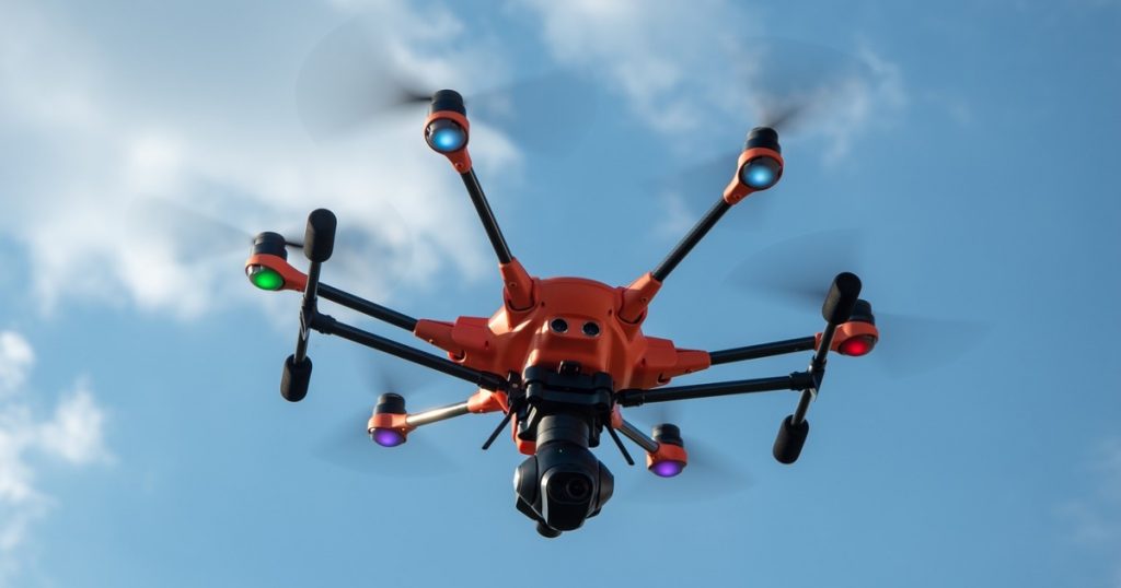
Yuneec H520:
Accomplished with precise thermal imaging capabilities, stability, and durability, the Yuneec H520 is a sturdy and dependable thermal drone. With its sophisticated flight control systems and high-resolution thermal camera, the H520 produces precise and clear thermal images in a variety of weather scenarios.
Owing to its attributes like intelligent flight modes, obstacle avoidance, and six-rotor redundancy, the H520 is an excellent choice for rigorous aerial inspection and surveillance jobs. Its adaptability to changing operational requirements is ensured by its modular design, which makes customization and upgrades simple.
Parrot Anafi Thermal:
Professionals in public safety, construction, and inspection can make use of the lightweight, compact Parrot Anafi Thermal thermal drone. With its integrated thermal imaging camera and 4K visual camera, the Anafi Thermal offers dual functionality for both thermal and visual inspections.
The Anafi Thermal is a small drone with amazing flying performance, with a maximum flight duration of up to 26 minutes and a transmission range of up to 4 kilometers. Its lightweight construction and foldable arms make it an excellent choice for applications needing flexibility and mobility as they make it easy to transport and use in the field.
Conclusion
Finally, thermal drones have shown themselves to be effective instruments with the ability to completely change a variety of industries. The capacity to obtain thermal images from the air offers significant perspectives on temperature fluctuations, heat sources, and anomalies, which are crucial for making informed decisions and resolving issues.
This article has covered the essentials of thermal drone technology, including its operation, uses, advantages, things to think about before buying, the best models available, rules, and potential legal ramifications. Thermal drones are incredibly useful for collecting, analyzing, and visualizing data for a wide range of applications, including search and rescue, building inspections, agriculture monitoring, and animal conservation.
Organizations can increase operational efficiency, strengthen safety protocols, and make better decisions across a range of industries by utilizing thermal drone technology. When buying and using thermal drones, it’s crucial to take regulation compliance, portability, camera resolution, battery life, and affordability into account.
The potential uses and advantages of thermal drones are anticipated to increase as long as technology is allowed to continue evolving and as long as innovations in thermal imaging technology spur new developments. Organizations can unlock new possibilities and achieve greater success in their endeavors by remaining informed, adjusting to changing regulations and best practices, and seizing the opportunities presented by thermal drones.